


Hot Selling Military Compass Outdoor Camping Equipment
Specification
| Model | DQL-7 |
| Outer circle measuring range | 0-360° |
| Dial scale | 1° |
| Reading error | ±1.5° |
| Inner circle measuring range | 60-00 mil |
| Dial scale | 0-20mil |
| Reading error | ±10mil |
| Measuring range | ±60° |
| Measuring proportion | ±2.5° |
| Proportion of odometer | 1:25000/1:50000/1:75000/1:100000 |
| size | 68x63x26mm |
| weight | 0.15KG |
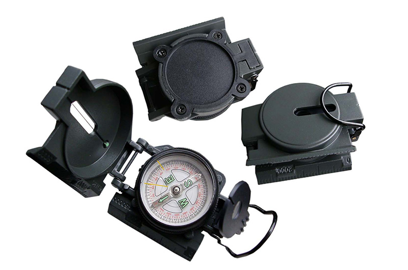
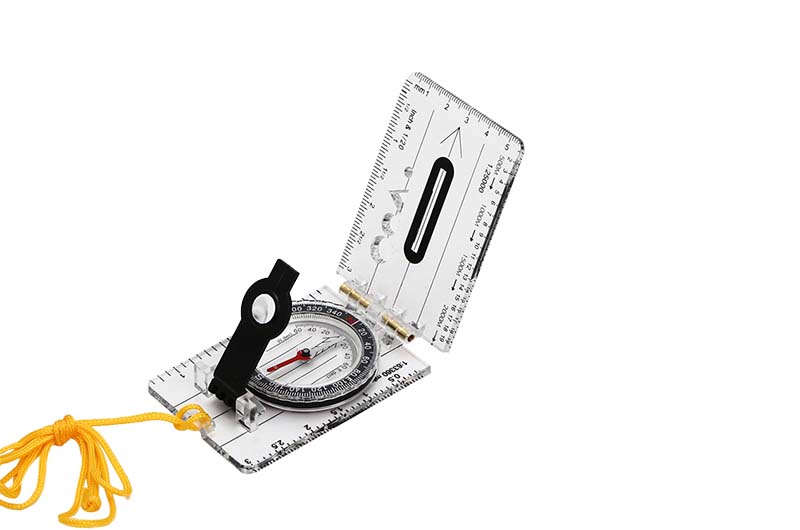
How to open the compass?
"Sine value table" is upward, and the cover can be opened without unscrewing any screws. As the hinge of the unused compass is relatively tight, it needs a little force to open
Usage method
1. Direction measurement
The strike is the horizontal projection direction of the dyke
Open the upper cover of the instrument to the limit position, adjust the magnetic declination angle of the area, place the two long sides of the instrument against the characteristic surface (representative surface) of the rock stratum, keep the round water bubble in the middle, read the degree indicated by the north pole of the magnetic needle, which is the trend of the rock stratum.
2. Test tendency:
Perpendicular to the direction of the face indicated by the strike. Use the short side of the site connecting the lower side of the hinge or the back of the upper cover to stabilize the characteristic surface of the rock layer, keep the circle horizontal and centered, then read the degrees indicated by the north pole of the magnetic needle, which is the trend of the rock layer
3. Inclination measurement
Angle perpendicular to strike horizontal plane
Open the upper cover to the limit position, the side of the instrument is perpendicular to the strike and close to the characteristic surface of the rock stratum, the lengthening bubble is in the middle, and the degree of the steering wheel indicated by the indicator is the dip angle of the rock stratum.
In actual measurement, only one of the two factors, trend and tendency, needs to be measured, because the relationship between trend and tendency is 90 °.
Topographic survey
1. Orientation
The direction and position of the target. Azimuth determination is also called rendezvous point.
Measurement method when the target is above the line of sight (horizontal line).
Hold the instrument tightly with the right hand, the back of the upper cover is facing the observer, and the arm is close to the body to reduce shaking. Adjust the long collimator and reflector with the left hand, and rotate the body so that the images of the target and the long collimation point are reflected into the reflector at the same time, not equally divided by the mirror line, and keep the round bubble in the center. Then read the degrees indicated by the north pole of the magnetic needle, which is the direction of the target.
2,Measuring slope angle
The angle between the target and the observer and the horizontal plane.
With the right hand holding the shell and site of the instrument, the long collimator is on the observer's side, the instrument plane is perpendicular to the horizontal plane, and the long blister is located below. With the left hand, adjust the upper cover and the long collimator, so that the target and the aiming tip holes are scored by the oval hole marking of the reflector at the same time. Then adjust the handle with the middle finger of the right hand, and observe that the long blister is centered from the reflector. At this time, the degree indicated by the indicator wheel on the steering wheel is the slope angle of the target. If the slope angle of a slope is measured, just open the upper cover to the limit position, place the side of the instrument directly on the slope, adjust the long bubble to the center, and read the angle, which is the slope toe of the slope.
3, Leveling line
Turn the long illuminator to a plane with the same surface, turn the upper cover to 90 °, and the aiming point is vertical and parallel to the upper cover. Align the indicator to "0", and the line of sight through the sight hole on the aiming point and the elliptical hole of the reflector is the horizontal line
Vertical angle of measuring object
Pull the upper cover to the limit position, use the side of the instrument to stick to the representative plane of the object, and then adjust the bubble to center. At this time, the degree of the indicator is the vertical angle of the object.