


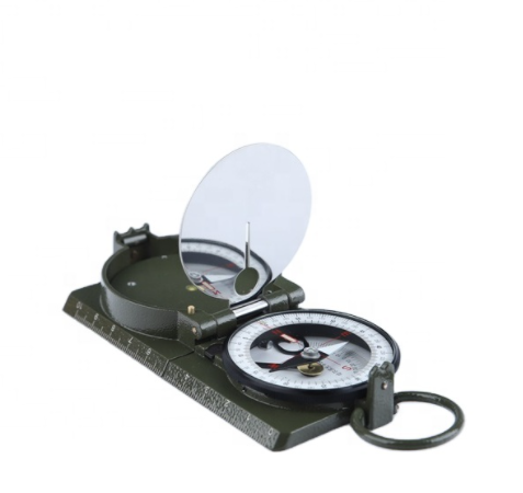
1.Use Model DQL-7 is for measuring azimuth, distance, slope, height and mileage. The instrument can also be used to measure the simple map. There's some luminous powder on the instrument's suitable parts for using it at night.
2.Structure The instrument is made up of compass and mileometer. The main parts are(see Fig1)
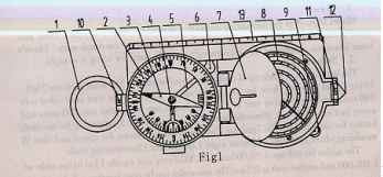
1) ring 2)azimuth support(There are two scales on it. The outside one is divided into 360 units and division unit is 1°. The inside one is divided into 300 units and every unit equals 20 mil.) 3)needle 4)angle measuring device 5)supporting for needle 6)button for stopping needle 7)mirror〖LM〗〖LM〗 8)milemeter9)measurig wheel 10)diopter 11)front sight 12)estimator 13)measuring scale.
2).The scales for milemeter are :1:25,000,1:50,000,1:75,000,1:100,000. The distance between the two tips of estimator:12.3mm. The distance between the diopter and estimator:123mm
3).Instructions for use
(1) Azimuthal orientation
(A) Establish the directions of the position where you are. Frist open the instrument's cover and make the azimuth tip “N" point “O", then turn the instrument till the needle's N pole points “O", and this is North. You can also know,East South and West in the same way.
(B)Establish the map's direction-making the map's direction be consistent with the direction of place where you are. Open the cover and turn the azimuth support till the azimuth tip “N" points the magnetic declination of your district. Then make the measuring scale 13)cut the true meridian on the map. After that move the map and make the needle's N pole point “N", in this case the directions on the map are consistent with your area's.
(C) Measuring magnetic azimuthal angle
(a) measuring the magnetic azimuthal angle of your district's target Open the cover, let the mirror be at an angle of 45°with azimuth support. Then put your thumb into the ring and keep the instrument being level. After that make the diopter, the front sight and the target be in the same line, at this time, the degrees on the azimuth support that needle's N pole points can be read in the mirror and this is the magnetic azimuthal angle's degrees of your district's target.
(b) measuring the magnetic azimuthal angle of the target on the map First adjust the map's direction according to actual direction, then put the measuring scale 13)on the line from the target to your position, thus the magnetic azimuthal angle can be got by the degrees that needle's N pole points after stopping the needle.
(2) Measuring distance
a) Read down the number from the measuring scale directly.
b) Measuring the distance on the map with milemeter First adjust the red pointer and make it point “O", then put the measuring wheel on the start point and move it from beginning to end along the line measured. Thus the distance can be got by reading the number on the mileometer according to different scales.
c) Measuring the distance from the position where you are to the target by the estimator. Because the length between the two tips on the estimator is 1/10 of the distance from the diopter to the front sight. So you can know the distance from the place where you are to the target by using similar triangle. (see Fig2).
If you know the distance L, you can know S:
S=L×1/10
If you know the length S, you can know L:
L=S×10
Note: this measuring method is only for skeleton survey.
(3) measuring the slope Open the cover of instrument and make the mirror be at an angle of 45°with azimuth support. And the line from diopter to front sight must be parallel with the slope. The angle measuring divice swings freely. In this case, you can read down the degrees from the slope dial in mirror.
(4) measurement of target's height If you know the distance L(See Fig2), first measure the slope, then you can calculate the target's height .
4. Notice
(1) Don't put the instrument near the magnetic objects.
(2) Keep the mirror clean.
(3) Close the instrument when it doesn't work.
Post time: Sep-16-2022